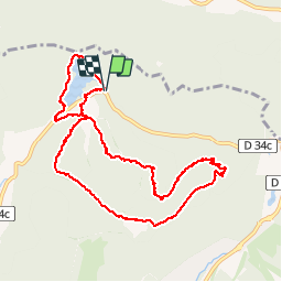
![](/images/other/stat-length.png)
![Trail Walking La Bresse - Lac de Lispach et sentier Dielaine - Photo](https://media.geolcdn.com/t/1900/400/b54731ea-6209-4cff-b7c0-af5225a4f3ae.jpg&format=pjpeg&maxdim=2)
Lac de Lispach et sentier Dielaine
zazie
User
![Length](/images/other/stat-length.png)
![Max alt](https://static1.geolcdn.com/siteimages/upload/files/1508320355ic_sort_altitude_max_24dp.png)
![Uphill gradient](https://static1.geolcdn.com/siteimages/upload/files/1508320355ic_sort_den_pos_24dp.png)
![Km-Effort](/images/other/stat-length.png)
![Min alt](https://static1.geolcdn.com/siteimages/upload/files/1508320355ic_sort_altitude_min_24dp.png)
![Downhill gradient](https://static1.geolcdn.com/siteimages/upload/files/1508320355ic_sort_den_neg_24dp.png)
![Boucle](https://static1.geolcdn.com/siteimages/upload/files/16400158638029165_repeat_loop_refresh_sync_direction_icon.png)
![Walking](https://static1.geolcdn.com/sitytour/trail-icons/101.png)
2h30
Difficulty : Medium
![Trail](https://static1.geolcdn.com/sitytour/trail-icons/104.png)
2h27
Difficulty : Difficult
![Scan this QR Code to open this trail in the SityTrail application](https://capi.geolives.com/qq0zvz2zws4bq2lad0pu/sitytour/trails/2122004/qr.png?size=200)
FREE GPS app for hiking
About
Trail Walking of 9.7 km to be discovered at Grand Est, Vosges, La Bresse. This trail is proposed by zazie.
Description
Après un tour du lac très bien aménagé, notamment pour quelques piques niques, la ballade se poursuit entre les pistes de ski alpin sur un sentier agréable et large. Après le point de vue peu dégagé, le retour se fait par le sentier Dielaine, petit frère du sentier des roches de la Schlucht. Il est très humide, quelques passages dans la roche, petits ponts suspendus. Le tout se termine au pied du tremplin à ski, fermé en été 😊.
Positioning
Comments
Trails nearby
![Trail Walking La Bresse - 2023-04-16 Marche Abri Lac de Blanchemer vers Lac de Lispach - Photo](https://media.geolcdn.com/t/375/260/20b642e6-a3a8-4790-bc8e-b2ad298c0408.jpg&format=jpg&maxdim=2)
![Walking Walking](https://static1.geolcdn.com/sitytour/trail-icons/101.png)
Walking
![](/images/other/stat-length.png)
![](https://static1.geolcdn.com/siteimages/upload/files/16400158638029165_repeat_loop_refresh_sync_direction_icon.png)
![Trail Walking La Bresse - 2023-04-15 Marche Abri Collet de Etang vers Abri Lac de Blanchemer - Photo](https://media.geolcdn.com/t/375/260/f5705708-8e73-435e-a1e8-28d1d0c03215.jpg&format=jpg&maxdim=2)
![Walking Walking](https://static1.geolcdn.com/sitytour/trail-icons/101.png)
Walking
![](/images/other/stat-length.png)
![](https://static1.geolcdn.com/siteimages/upload/files/16400158638029165_repeat_loop_refresh_sync_direction_icon.png)
![Trail Walking La Bresse - Kastelberg des pierres, des lacs, des panoramas magnifiques - Photo](https://media.geolcdn.com/t/375/260/cada329c-fae7-4d3f-815e-38ed5d6ce361.jpg&format=jpg&maxdim=2)
![Walking Walking](https://static1.geolcdn.com/sitytour/trail-icons/101.png)
Walking
![](/images/other/stat-length.png)
![](https://static1.geolcdn.com/siteimages/upload/files/16400158638029165_repeat_loop_refresh_sync_direction_icon.png)
![Trail Walking Gérardmer - gerardmer - la mauselaine . tête grauvelin . Roche boquet . croix claudé . hautes Vannes . la mauselaine - Photo](https://media.geolcdn.com/t/375/260/52e7d67b-2c25-481b-9a23-f7923e7ada1d.jpg&format=jpg&maxdim=2)
![Walking Walking](https://static1.geolcdn.com/sitytour/trail-icons/101.png)
Walking
![](/images/other/stat-length.png)
![](https://static1.geolcdn.com/siteimages/upload/files/16400158638029165_repeat_loop_refresh_sync_direction_icon.png)
![Walking Walking](https://static1.geolcdn.com/sitytour/trail-icons/101.png)
Walking
![](/images/other/stat-length.png)
![](https://static1.geolcdn.com/siteimages/upload/files/16400158638029165_repeat_loop_refresh_sync_direction_icon.png)
![Trail Walking La Bresse - lac de Lispach - Photo](https://media.geolcdn.com/t/375/260/ext.jpg?maxdim=2&url=https%3A%2F%2Fservices.sitytrail.com%2FGeolivesWS%2FDownloadMedia.ashx%3FTrailID%3D441673%26Media%3D20150705125536.jpg)
![Walking Walking](https://static1.geolcdn.com/sitytour/trail-icons/101.png)
Walking
![](/images/other/stat-length.png)
![](https://static1.geolcdn.com/siteimages/upload/files/16400158638029165_repeat_loop_refresh_sync_direction_icon.png)
![Trail Walking La Bresse - lac de Lispach - Photo](https://media.geolcdn.com/t/375/260/ext.jpg?maxdim=2&url=https%3A%2F%2Fservices.sitytrail.com%2FGeolivesWS%2FDownloadMedia.ashx%3FTrailID%3D441672%26Media%3D20150705124703.jpg)
![Walking Walking](https://static1.geolcdn.com/sitytour/trail-icons/101.png)
Walking
![](/images/other/stat-length.png)
![](https://static1.geolcdn.com/siteimages/upload/files/16400158638029165_repeat_loop_refresh_sync_direction_icon.png)
![Trail Mountain bike La Bresse - randonnée découverte à la Bresse. - Photo](https://media.geolcdn.com/t/375/260/ext.jpg?maxdim=2&url=https%3A%2F%2Fservices.sitytrail.com%2FGeolivesWS%2FDownloadMedia.ashx%3FTrailID%3D435768%26Media%3Dfix__20150620120320.jpg)
![Mountain bike Mountain bike](https://static1.geolcdn.com/sitytour/trail-icons/202.png)
Mountain bike
![](/images/other/stat-length.png)
![](https://static1.geolcdn.com/siteimages/upload/files/16400158638029165_repeat_loop_refresh_sync_direction_icon.png)
![Trail Walking Ban-sur-Meurthe-Clefcy - La vallée de Belbriette - Ban-sur-Meurthe-Clefcy - Photo](https://media.geolcdn.com/t/375/260/ext.jpg?maxdim=2&url=https%3A%2F%2Fservices.sitytrail.com%2FGeolivesWS%2FDownloadMedia.ashx%3FTrailID%3D172951%26Media%3D14431_5.jpg)
![Walking Walking](https://static1.geolcdn.com/sitytour/trail-icons/101.png)
Walking
![](/images/other/stat-length.png)
![](https://static1.geolcdn.com/siteimages/upload/files/16400158638029165_repeat_loop_refresh_sync_direction_icon.png)
Merci pour cette belle randonnée.